On My Tracks (by Roberto Emiliani)
| Indra Trek and Travel - Design, photos and implementation by Lucio Magi © 2007 |
Best viewed with Mozilla Firefox |
 Parco Sasso Simone e Simoncello 3.5 Km Trekking GMaps | Casentino 9 Km Trekking GMaps | Monte Cucco 11 Km Trekking GMaps | Casentino 10km Trekking GMaps |  Gola della Rossa 16 km Trekking GMaps |
Redentore Valle Santa Ghiaccio M. Redentore 5km Trekking GMaps | M Cucco 16km Trekking GMaps | Leccia
Trekking GMaps | Chioaserna - Catria 12 km Trekking GMaps |
Hi everybody,
you will find here several trails tracked in different times; wandering around the mountains hunting for refilling silences and emotions, emptying the soul from anything unnecessary.
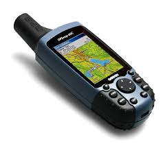
The GPS devices used for tracking are a Garmin IV and a TwoNav Aventura, both more than reliable. The tracks are meant to be just a help and a direction for the trail you are willing to take; they are here just to give you a hint for your next roundabout and to guide you in case you lose the trail. In the mountains, as in all journeys, you must be able to measure your resources and know your limits to avoid getting into trouble. A section of the trail too exposed, an unexpected mountaineering route or a simple climb too steep could make our life difficult or create problems in who came with us and trusted our choices. So please take our "trackpoints" and our notes just as a guide to your chosen path and enjoy all the rest. Remember to always have the necessary equipment to face the trail and above all trust always your sense of orientation and a good paper map, that should never be missing from your backpack: as much as a GPS device can be accurate and reliable, it can always fail or worse, since batteries do not last forever, can let you down when it shouldn't. Have a wonderful trail.
Roberto
you will find here several trails tracked in different times; wandering around the mountains hunting for refilling silences and emotions, emptying the soul from anything unnecessary.
The GPS devices used for tracking are a Garmin IV and a TwoNav Aventura, both more than reliable. The tracks are meant to be just a help and a direction for the trail you are willing to take; they are here just to give you a hint for your next roundabout and to guide you in case you lose the trail. In the mountains, as in all journeys, you must be able to measure your resources and know your limits to avoid getting into trouble. A section of the trail too exposed, an unexpected mountaineering route or a simple climb too steep could make our life difficult or create problems in who came with us and trusted our choices. So please take our "trackpoints" and our notes just as a guide to your chosen path and enjoy all the rest. Remember to always have the necessary equipment to face the trail and above all trust always your sense of orientation and a good paper map, that should never be missing from your backpack: as much as a GPS device can be accurate and reliable, it can always fail or worse, since batteries do not last forever, can let you down when it shouldn't. Have a wonderful trail.
Roberto